Floodplain Introduction
Back to top
These pages provide Harris County residents with information and resources regarding flooding, and establish easy access to Harris County’s regulations and programs related to flooding and floodplain management.
Floods are one of the most common hazards in the United States. Flood effects can be local, impacting a neighborhood or community, or very large, affecting entire river basins and multiple states. It is important to be aware of flood hazards no matter where you live. Even very small streams, gullies, creeks, culverts, dry streambeds, or low-lying ground that appears harmless in dry weather can flood.
Additional information on flood insurance coverage and requirements, flood protection measures, flood safety, and property and building protection is available in floodplain “libraries” maintained by Harris County both at the Harris County Permit Office and the 26 branches of the Harris County Public Library. Property owners can take actions in advance of a flood to provide protection for their property. Floodplain maps and helpful FEMA publications “Design Guidelines for Flood Damage Reduction” and “Homeowner’s Guide to Retrofitting” are in these libraries, as are a number of other useful documents.

Use the map below to search for a location and view the floodplain information for that area.
Flood Facts
Back to top
Risk
- Floods are the #1 natural disaster in the United States.
- Just an inch of water can cause costly damage to property. As little as six inches of moving water can knock you off your feet or move your car.
- Everyone is at risk.
- Most homeowners insurance doesn't cover flood damage.
- More than 50 percent of properties in high-risk areas remain unprotected by flood insurance; all properties in high-risk areas need to be protected with flood insurance.
- Between 20 and 25 percent of all flood insurance claims are filed in low-to moderate-risk areas.
- New construction can increase flood risk, especially if it changes natural runoff paths.
- More than 5 million Americans are protected with flood insurance but millions more are unaware of their personal risk for property damage or options for protection.
- For building in high flood risk areas, there is a 26 percent chance of experiencing a flood during the life of a 30-year mortgage, compared to a nine percent chance of experiencing a fire.
Impact
- Flood losses in the United States averaged $2.4 billion per year for the last decade.
- The National Flood Insurance Program (NFIP) has paid nearly $16 billion in flood insurance claims to policyholders during the 2005 hurricane season (as of August 31, 2006.)
- Federal disaster assistance is usually a loan that must be paid back with interest and is only available when a disaster has been federally declared.
- In the last 52 years, nearly 1,000 flood events have been designated as federally declared disasters.
- Nearly 75 percent of all federally declared disasters over the past five years involved flooding.
Harris County Floodplain
Back to top
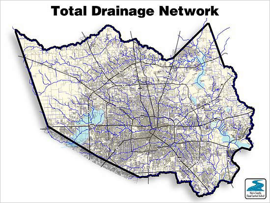
Harris County is the third largest county in the United States with a population greater than three million. It covers 1,788 square miles with 1,500 channels totaling about 2,500 miles in length within twenty-two watersheds. The land use consists of urban, residential, commercial, and heavy industrial areas. In the last century, over 30 thunderstorms, tropical storms, and hurricanes have caused flooding in Harris County. Each bayou and creek include areas known as "floodplains," where water collects, pools, and flows during the course of a natural storm event.
A floodplain is defined as any land area susceptible to being inundated by water from any source. These areas are classified as Special Flood Hazard Areas (SFHA), and are located in a 100-year flood zone. The term "100-year flood" can be misleading. It does not mean that the flood will occur every 100 years; rather it is the flood elevation that has a 1- percent chance of being equaled or exceeded each year. Harris County has Flood Insurance Rate Maps (FIRM) that identify all floodplain areas within the county limits.
Harris County strives to protect the natural and beneficial functions of floodplain areas. Harris County has some unique situations. After devastating flooding in 1935, the state legislature created the Harris County Flood Control District (HCFCD). As stated in the Flood Insurance Study, HCFCD governs drainage and flood control, while the county engineer governs floodplain management and permit programs with technical assistance from HCFCD. Although both agencies are under the jurisdiction of Commissioners’ Court, they are separate agencies. In 2003, Harris County Commissioners’ Court adopted the Draft Floodplain Management Plan for qualification to participate in the National Flood Insurance Program’s (NFIP) Community Rating System (CRS).

Floodplain Maps
Back to top
Flood hazard maps, also called "Flood Insurance Rate Maps" or "FIRMs" are important tools in the effort to protect lives and properties in Harris County. By showing the extent to which areas of the County and individual properties are at risk for flooding, flood maps help business and property owners make better decisions about protecting their property. These maps also allow engineers, community planners, local officials, builders and others to make important determinations about where and how new structures and developments should be built. Flood Insurance Rate Maps are used to determine the flood risk to your home or business. The low and moderate-risk zones are represented on the maps by the letter "X". The inland high-risk zones will be labeled "A", "AE" or "AO".
If you would like to research the flood hazards near your home or business, please access the Harris County Flood Control District's Interactive Map www.harriscountyfemt.org .
If you would like to find out whether or not your property is located within a special flood hazard area, please contact the Harris County Permit Office at 713-274-3900 for an unofficial determination. This service is provided free of charge for properties located within unincorporated Harris County limits.
You can also view copies of the Flood Insurance Rate Maps in the Harris County Permit Office.

Flood Insurance
Back to top
Unlike most standard homeowner's policies, flood insurance covers losses to your property caused by flooding. Property owners, renters and businesses can purchase flood insurance through the National Flood Insurance Program (NFIP) as a result of Harris County’s participation in the program. By participating in the NFIP, communities are required to adopt sound floodplain management ordinances to reduce future flood damage. In exchange, the NFIP provides federally backed flood insurance at affordable rates.
Communities that participate in the NFIP are rated by the Federal Emergency Management Agency (FEMA) through the Community Rating System (CRS). FEMA encourages communities to implement floodplain management standards which exceed the minimum NFIP standards. In return, FEMA rewards communities with higher standards by offering a discount on flood insurance policies.
The current Harris County CRS rating is an 7. This rating gives residents a 15% discount on non-preferred risk flood insurance policies. (For more information about the rating system please visit www.FloodSmart.gov.)
Why Purchase Flood Insurance?
Flood insurance is required by law for property owners living in a high-risk area, or Special Flood Hazard Area, with a federally backed mortgage. For example, if you have a FHA or VA loan, or if your mortgage company is federally insured, you must obtain flood insurance if you live in a high risk area. Regardless of the type of mortgage, Harris County recommends that all residents in high-risk areas be protected. For buildings in high flood risk areas, there is a 26% chance of experiencing a flood during the life of a 30-year mortgage, compared to a 9% chance of experiencing a fire.
Remember that everyone has some risk of flooding. Flooding events can also occur in low-to-moderate risk areas and flood insurance in these areas is also strongly recommended. Most homeowners' policies do not cover flood losses.
How Much Does Flood Insurance Cost?
The average premium for a yearly flood insurance policy is approximately $500. People in low-to-moderate risk areas may be eligible for the Preferred Risk Policy with flood insurance premiums as low as $119 a year. Contact your insurance agent for more details.
How Do I Purchase Insurance?
Flood insurance is sold through more than 85 private insurance companies and agents, and is available to homeowners, business owners, and renters. Contact your insurance agent to help you decide what kind of flood protection is best for you. Information on how to purchase a flood insurance policy is also available at www.FloodSmart.gov.
Property Protection Measures
Back to top
Home and business owners can protect themselves from future floods or reduce the effect of future floods by various means including:
- Elevating the structure
- Floodproofing the structure
- Facilitating future evacuations
- Buying flood insurance
- For more information on protecting your property from flood damage, please visit the FEMA website.
Additional information on flood protection measures and building protection is also available in floodplain "libraries" maintained by the Harris County both at the 26 branches of Harris County Public Library and at Harris County Permit Office.
Localized Drainage Concerns (Residential Properties)
Under Texas Water Law, "No person may divert or impound the natural flow of surface waters in this state, or permit a diversion or impounding by him to continue in a manner that damages the property of another by the overflow of the water diverted or impounded." Essentially, this means that the natural path of storm water runoff is not to be blocked.
- If you have experienced minor flooding in your home or ponding water in your yard, you may simply have a localized drainage problem that can be corrected with minor grading.
- Property owners are responsible for runoff from private property or between private properties.
- Become familiar with your lot's intended drainage pattern. In most cases, the runoff is intended to flow to the street around each side of the home. In some cases, portions of your lot may naturally drain onto a neighbor's lot, or perhaps you have neighbors whose yard drains onto yours.
- Before you decide to make landscaping improvements to your yard, including the construction of a pool, make sure that you are not blocking the path of storm water runoff and inadvertently causing damage to your property, or the surrounding properties.
- The Harris County Permit Office has experienced staff members available to offer suggestions which might alleviate minor drainage problems. Call 713-274-3900 to speak with a representative.
- Consider purchasing flood insurance, even if your property is not within a FEMA designated Special Flood Hazard Area. Most homeowner's insurance does not cover damages caused by flooding. Harris County recommends that all residents purchase flood insurance, even if it is not mandated by your home mortgage company. Every year, 25% of flood damages occur on properties outside of the floodplain.
Flood Safety
Back to top
Nobody can stop a flood, but there are actions you can take before, during, and after a flood to protect your family and keep your property losses to a minimum.
BEFORE THE FLOOD
Stay Tuned
Listen to your radio, TV, or National Weather Service radio for the latest information on weather conditions that can cause flooding. Learn about NOAA Weather Radios by clicking here.
Learn and Understand the Difference:
- Flash Flood Warning - Flash flooding has been reported.
- Flash Flood Watch - Conditions exist that may lead to flash flooding.
- Urban and Small Stream Advisory
- Flooding of small streams, streets, and low-lying areas is occurring.
Stay Alert
Avoid unnecessary travel during severe weather. Poor visibility can make trips dangerous. Warn children not play near swollen creeks, storm drains, or culverts.
Do not go near creeks and low-water crossings. Beware of rising, swift-moving water. Creeks can rise to dangerous levels in as little as one hour. Man-made features such as storm drains, fences, and culverts create additional "strainers" that can snag and drown even the strongest swimmer.
If you see major obstructions such as downed trees or telephone poles in a creek, or if you see a blocked culvert or bridge opening, call (713) 684-4000.
If Time Allows...and Your House Is In the Path of the Flood:
- Turn off all utilities at the main power switch and close the main gas valve if evacuation appears necessary.
- Move valuables, such as papers, furs, jewelry, and clothing to upper floors or higher elevations.
- Fill bathtubs, sinks, and plastic soda bottles with clean water. Sanitize the sinks and tubs first by using bleach and rinsing.
- Bring outdoor possessions, such as lawn furniture, grills, and trash cans inside, or tie them down securely.
DURING THE FLOOD
Stay Away
Do not drive or walk into water that is flowing across low water crossings, bridges, or roadways. If you come upon a flooded road, turn around and go another way. Heed all warnings and street barricades - if you go around once, you are subject to a fine. For more information on road closures, call (713) 881-3000.
These areas are especially dangerous because:
- As little as six inches of moving water can knock you off your feet or move your car.
- More people drown in their cars than anywhere else.
- The road may be washed out below the water surface.
- Your car may stall or get stuck in the water, and then get pushed off the road. Once off the road, cars often start to roll, making escape impossible.
- Do not go near downed power lines and electrical wires. Electrocution is another major source of deaths in floods.
Move to a Safer Area
Evacuate your house if instructed to do so. Follow emergency instructions. It is much safer and easier to evacuate before flood waters become too deep.
If the waters start to rise inside your house before you have evacuated, retreat to the second floor, attic or roof. Take dry clothing, a flashlight, and a portable radio.
AFTER THE FLOOD
Call Your Agent
If your home, apartment, or business has suffered damage, call the insurance company that handles your flood insurance policy right away to initiate a claim.
Document Damage
Take color photographs or video of any damages resulting from the flood.
Before Entering a Flooded Building
- Check for structural damage. Don't go in if there is any chance of the building collapsing.
- Do not use matches, cigarette lighters, or any other open flames, since gas may be trapped inside. Instead, use a flashlight to light your way.
- Keep power off until an electrician has inspected your system for safety.
- Look out for animals and snakes. Animals lose their homes in floods too. They may seek shelter in yours.
Boil Water
Until local authorities proclaim your water supply to be safe, boil water for drinking and food preparation. Water should be boiled vigorously for five minutes before using.
Careful Cleaning
Flood waters pick up sewage and chemicals from roads, farms, and factories. If your home has been flooded, protect your family's health by cleaning up your house right away. Throw out foods and medicines that may have come into contact with flood water.
Be careful walking around. After a flood, steps and floors are often slippery with mud and covered with debris, including nails and broken glass.
Floodplain Development
Back to top
Structures within the Special Flood Hazard Area (SFHA) in a community participating in the National Flood Insurance Program (NFIP) are subject to Floodplain Management Regulations that impact building standards and are designed to minimize flood risk. In addition to federal standards, Harris County has Floodplain Management Regulations more stringent than the federal standards in place which govern development within the SFHA. These standards apply to new structures and to substantial improvements of existing structures. Harris County defines a substantial improvement as any reconstruction, rehabilitation, or addition to an existing structure, the cost of which exceeds 50 percent of the structure's appraised or market value.
Key components of Floodplain Development:
- A Floodplain Development Permit is required for all work in the floodplain.
- A post construction finished floor Elevation Certificate is required for structures within the SFHA. This certification must be made by a Texas Registered Professional Surveyor, Engineer or Architect. The Elevation Certificate form and instructions can be downloaded by clicking the FEMA link, or a copy can be picked up at the Harris County Permit Office.
- The Finished Floor elevation of structures within the SFHA must be a minimum of 18" above the Base Flood Elevation (BFE).
Floodplain Development Permit
Any activity performed in the floodplain must have a Floodplain Development Permit. This includes grading, filling, residential construction and commercial construction.
To obtain a permit you must complete a residential Permit Application and comply with Floodplain Management Regulations. Residential Permit Applications can be picked up at the Harris County Permit Office or downloaded from the Harris County Permits website. Complete and return the form along with 3 sets of plans of the project to the Harris County Permit Office. The plans must clearly show existing and proposed contours at the site with all elevations submitted on NAVD 2001 datum.
If the structure is currently located in or adjacent to a FEMA designated SFHA the applicant must submit two Elevation Certificates:
- With the form board survey before the slab is poured, AND
- A post construction Finished Floor elevation certification
These certifications must be made by a Texas Registered Professional Surveyor, Engineer or Architect. This must confirm that the finished floor of the actual construction is at least 18-inches above the BFE. Copies of previously submitted elevation certificates are available at the Harris County Permit Office.
Residents/Homeowners/Business Owners
If your property lies within the SFHA, a Residential Permit Application and compliance with Floodplain Management Regulations is required for any work, including:
- Grading
- Filling
- Paving
- Construction of new structures including additions to the home
- Miscellaneous (pools, gazebos, retaining walls, fences, etc.)
You may be required to bring your home or business into compliance with current Floodplain Management Regulations development standards if:
- Your home or business has been significantly damaged due to flooding, resulting in the need for substantial improvements, OR
- You are proposing substantial improvements to your home or business such as an addition or renovation.
County staff is available to make site visits, if requested, to review flooding and drainage issues. Contact the Harris County Permit Office at 713-274-3900 for further information and prior to undertaking any activity within the floodplain.
Drainage System Maintenance
Back to top
What is Storm Water?
The term storm water refers to rainwater. Storm water washes down storm drains on the curbs of roads and leads directly into lakes, rivers, and streams. Unlike wastewater, it is untreated and can carry pollutants, sediments, and trash directly into our natural water resources.
As storm water runoff travels over the land, it picks up all kinds of chemicals, waste, and trash that are not naturally found in our waterways. Storm water runoff enters the storm drain system through inlets, and discharges untreated into creeks, bayous, channels, lakes, and rivers. Some chemicals and other substances in storm water can be toxic, even at small levels, endangering plants and animals that depend on the water to survive. Pollution of our waterways can also mean we cannot boat, swim, or fish because it is unpleasant or even unsafe.
Storm water runoff from properties throughout Harris County flows to one of 1,500 channels totaling about 2,500 miles in length within twenty-two watersheds of Harris County, joining Galveston Bay and flowing downstream to the Gulf of Mexico.
Storm water pollution can be controlled if everyone plays a part in preventing these substances from entering the storm drain inlets in the streets where they live and work. You can help prevent storm water pollution by eliminating illicit discharges, exercising responsible use of herbicides, pesticides, and fertilizers in lawn and landscape maintenance, and proper disposal of used oil and toxic materials.
What Can We Do?
Please do your part to keep inlets and drainage ways clear of brush and debris. Here are steps you can take to protect the quality of water in Harris County’s bayous, creeks and channels:
1. Maintain your vehicle so hoses and reservoirs do not leak or break causing fluids to spill onto streets. Don't pour used motor oil, antifreeze, old pesticides or any other pollutants into the storm drainage system.
2. Use a mulching mower or bag your grass and leaves instead of blowing the yard waste into the street. Yard waste can clog storm drains.
3. Pick up litter around your neighborhood or business so that trash doesn't collect on drainage inlets or clog storm sewer pipes.
4. If you spot a blocked drain or notice illegal dumping, call the Harris County Precinct Office in your area, and someone will investigate. Putting foreign substances into the storm sewer is a violation of Harris County Storm Water Quality Regulations and may result in a fine.
- Storm Drains and Roadside ditches in Precinct 1 call (713) 991-6881
- Storm Drains and Roadside ditches in Precinct 2 call (713) 455-8104
- Storm Drains and Roadside ditches in Precinct 3 call (281) 463-6300
- Storm Drains and Roadside ditches in Precinct 4 call (281) 353-8424
- All Channels, Bayous and Creeks call HCFCD at (713) 684-4000
Our Drainage System
Harris County and Harris County Flood Control District maintain our county-wide system of drainage improvements, including 1,500 channels totaling about 2,500 miles in length within twenty-two watersheds. When the drainage system is overwhelmed, "localized flooding" can be the result. The drainage system consists of:
- Channels
- Creeks
- Bayous
- Roadside ditches
- Culverts
- Curb inlets
- Manholes
- Storm drain pipes
Harris County Flood Control District has a drainage maintenance program in which crews clean out debris that has collected within channels.
Flood Map Modernization
Back to top
Harris County and the FEMA have updated all of the Flood Insurance Rate Maps (FIRMs) for Unincorporated Harris County. Harris County adopted the effective FIRMs dated June 18, 2007. The Map Modernization project provides property owners throughout Harris County with up-to-date, reliable, Internet accessible information about their flood risk on a property by property basis. Please visit Harris County Flood Control District's Interactive Map to see how the FEMA updated floodplain boundaries impact your property.
It is important to note that the calculated flood levels (based on extensive hydraulic modeling) in Harris County are not changing with the issuance of the maps. Rather, more accurate survey information is allowing FEMA to show the limits of the floodplain more accurately than ever before. In other words, properties which are now shown on the map to be within the floodplain were actually always within the floodplain. No physical features have changed which adversely impacted the properties and caused the shift in floodplain limits. The acquisition of better data revealed that the existing maps, some of which are up to 12 years old, were not correct. The risk was always there; FEMA is now making the public aware of it.